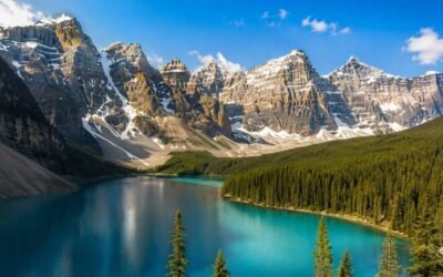
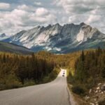
The Icefields Parkway is one of those drives that ruins other drives for you. After you've done it once, regular highways feel like something is missing. The 232 km stretch of Highway 93 North between Lake Louise and Jasper is consistently ranked among the most scenic drives in the world — and once you're on it, you understand exactly why. Glaciers spill down from the peaks. Lakes the colour of unmixed paint sit beside the road. Waterfalls thunder off cliffs. And every 15 minutes, another view appears that makes you slow the car down without thinking about it.
But here's the thing most people don't realize until they're already driving it: there are way too many stops to do in a single day. If you try to see everything, you'll spend more time in parking lots than at the actual viewpoints. The smart approach is to pick the best 10 stops, plan your day around them, and let the rest be a bonus.
This guide is based on the research I've done, the routes I've driven, and what I've learned from other Albertans about which stops actually deliver — and which ones look better on paper than in real life. I've listed them in driving order from Lake Louise heading north to Jasper, with honest notes about each one..
A Few Things to Know Before You Drive the Icefields Parkway
Before you start, here are the practical things that will save you a lot of frustration.
- Fill up before you go. There's only one gas station on the entire 232 km route, at Saskatchewan River Crossing, about halfway through. Prices there are notoriously expensive. Fill up in Lake Louise or Jasper before you start driving.
- Cell service is unreliable. Most of the parkway has no signal. Download offline maps before you leave.
- You need a Parks Canada pass. A Discovery Pass or a daily pass is required to stop anywhere along the parkway. Bonus for 2026: Parks Canada has made admission free from June 19 to September 7, 2026, as part of the Canada Strong Pass program.
- Allow a full day. The drive takes 3 to 3.5 hours non-stop, but realistically, you need 8 to 10 hours to enjoy the major stops without rushing. Better yet, stay overnight near the Columbia Icefield and split the drive over two days.
- Best time to drive: Summer (mid-June to early September) when all viewpoints, trails, and facilities are open. Winter driving is possible but conditions change fast, and the road can close during snowstorms.
- Start early. Parking lots at popular stops like Peyto Lake and Bow Lake fill up by 9 or 10 AM in summer. Leaving at sunrise makes a huge difference.
The 10 Best Icefields Parkway stops
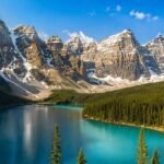
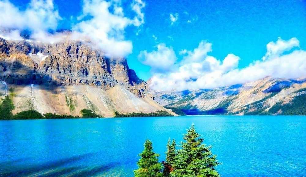
1. Bow Lake and the Crowfoot Glacier Viewpoint
- Distance from Lake Louise: 35 km (about 30 minutes)
- Time needed: 30 minutes to 2 hours
- Difficulty: Easy — wheelchair-accessible viewpoints
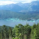
Bow Lake is one of the largest lakes in Banff National Park and one of the most photographed stops along the parkway. The water is a striking turquoise blue, fed by glacial melt from the Wapta Icefield and the Bow Glacier above. From the parking lot, you can walk right down to the shoreline in about 2 minutes.
Just a few kilometres before Bow Lake, you'll pass the Crowfoot Glacier Viewpoint, a roadside pullout with a clear view of the glacier that's shaped like a crow's foot (or used to be, before climate change melted one of the toes). It's worth a 5-minute stop for photos.
The historic Num-Ti-Jah Lodge at the north end of Bow Lake is one of the most photogenic mountain lodges in the Rockies, with a bright red roof, white walls, and sitting right on the lake. Even if you're not staying, drive over for the view.
Important 2026 update: Due to a major rockfall in summer 2025 near Bow Glacier Falls, the Bow Glacier Falls trail is closed until at least the end of 2026. The lake itself remains open and accessible.
Honest tip: Arrive before 9 AM. The parking lot fills quickly in summer.
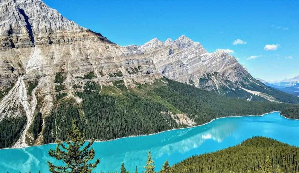
2. Peyto Lake and Bow Summit
- Distance from Lake Louise: 40 km (about 35 minutes)
- Time needed: 45 minutes to 1.5 hours
- Difficulty: Easy — 1.5 km uphill paved walk to the lookout
This is the postcard view of the Icefields Parkway. Peyto Lake sits in a valley below Bow Summit, the highest point on the parkway at 2,088 metres. From above, the lake is shaped like a wolf's head, and its colour is somewhere between teal and electric blue.
The lake itself isn't visible from the parking lot — you have to walk a paved uphill trail for about 15 minutes to reach the main lookout. The trail was rebuilt with a wider, more accessible viewing platform a few years ago, which has helped manage the crowds.
Honest tip: Mid-day in July and August, the upper viewpoint is genuinely packed. If you can, visit at sunrise or after 6 PM for fewer people. The colour is most vivid in late June through August when glacial silt is at its peak.
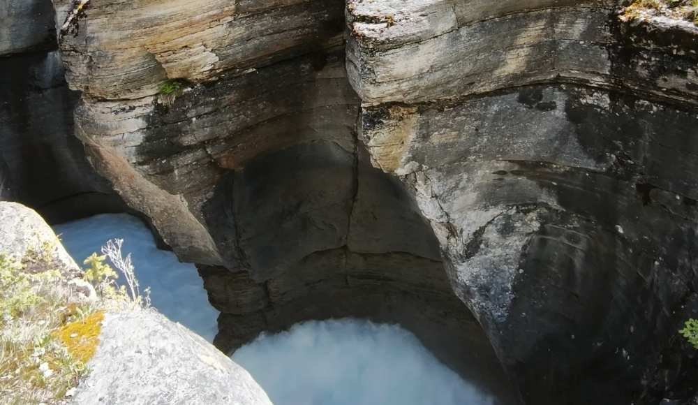
3. Mistaya Canyon
- Distance from Lake Louise: 71 km (about 1 hour)
- Time needed: 30 minutes to 1 hour
- Difficulty: Easy — 0.5 km walk to the bridge
If you only have time for one short hike on the parkway, make it Mistaya Canyon. The walk from the parking lot to the bridge takes about 10 minutes through a pine forest. Once you're there, you're standing directly above a dramatic slot canyon carved by the Mistaya River.
The water roars 20 metres below you. The limestone walls curve and twist into smooth shapes. Most visitors spend 30 minutes here, then continue north.
Honest tip: Mistaya Canyon has unfenced edges, and the rocks are slippery. Stay back from the canyon rim — several people have died here. View from the bridge only is advised.
For the full breakdown, see this post about the Mistaya Canyon guide.
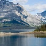
4. Saskatchewan River Crossing
- Distance from Lake Louise: 77 km (about 1 hour 10 minutes)
- Time needed: 30 minutes for a quick break, up to 1 hour for a meal
Saskatchewan River Crossing is the only commercial stop on the entire parkway. There's a gas station, a small cafe and restaurant, washrooms with running water, a convenience store, and souvenir shop. It's not pretty, but it's essential, especially if you didn't fill up before you left.
The crossing itself is historically and geographically interesting: this is where three rivers meet (the North Saskatchewan, the Howse, and the Mistaya), and it sits below dramatic mountain views. There's a viewpoint just across the highway worth a quick photo stop.
Honest tip: Gas here is significantly more expensive than in Banff, Lake Louise, or Jasper. Fill up before you start the parkway if you can. The cafe food is functional, not memorable, so pack your own lunch if possible.
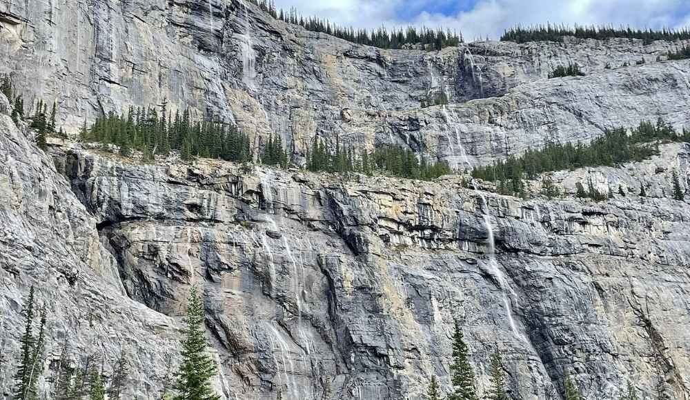
5. The Weeping Wall
- Distance from Lake Louise: 110 km (about 1 hour 30 minutes)
- Time needed: 5 to 10 minutes (roadside viewpoint)
- Difficulty: No hiking — you stay in your car
A few kilometres past Saskatchewan River Crossing, you'll see a massive cliff on your right with multiple waterfalls cascading down its face. This is the Weeping Wall, a stretch of dark limestone where water seeps out of the rock and falls as a curtain of streams.
In summer, the water flows in dozens of thin streams. In winter, the whole wall freezes into a sheet of blue ice, and it becomes one of the most popular ice climbing destinations in the world.
The biggest waterfall in the formation is called "Teardrop."
Honest tip: This is a quick roadside stop; 5 to 10 minutes is plenty. Pull off at the marked viewpoint on the left side of the highway (when driving north). Don't try to stop on the shoulder.
6. The Big Bend and the Big Hill
- Distance from Lake Louise: 115 km (about 1 hour 40 minutes)
- Time needed: 10 to 15 minutes
- Difficulty: Roadside views
Right after the Weeping Wall, the parkway climbs dramatically up to the Sunwapta Pass. The road bends sharply in a switchback called the Big Bend, and the section of steep highway leading up to it is known as the Big Hill.
At the top, there's a pullout with a stunning view back south down the valley you just drove through. It's one of the most underrated photo stops on the parkway because most travellers just blow past it on the climb. Stop at the top, look back, and take the photo.
Honest tip: The Big Bend is also a great spot to see mountain goats on the cliffs. Bring binoculars and scan the rock faces.
7. Parker Ridge Trail
- Distance from Lake Louise: 117 km (about 1 hour 45 minutes)
- Time needed: 2 to 3 hours for the hike
- Difficulty: Moderate — 5.2 km return with 270 metres of elevation gain
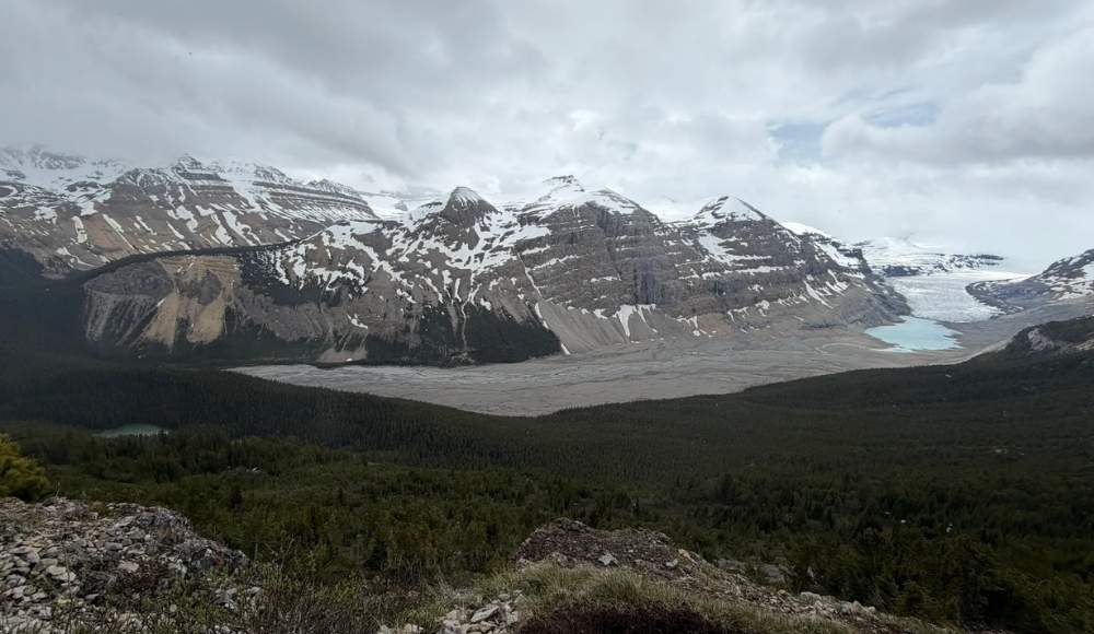
If you have time for one real hike on the parkway, Parker Ridge is the one. The trail switchbacks up an alpine ridge and tops out with a sweeping view of the Saskatchewan Glacier, one of the largest valley glaciers in the Rockies, stretching out below you.
The hike is short but steep, and the trail is mostly above tree line, so the views start almost immediately. In summer, the ridge is covered in wildflowers. In late September, the surrounding larches turn golden.
Honest tip: It can be windy and cold at the top even on warm days. Bring a windproof jacket, hat, and gloves regardless of the season. The trail is usually accessible from July through September.
8. Columbia Icefield and the Athabasca Glacier

- Distance from Lake Louise: 132 km (about 2 hours)
- Time needed: 1 to 3 hours
- Difficulty: Easy walking; tours range from easy to moderate
The Columbia Icefield is the largest icefield south of the Arctic Circle, covering 325 square kilometres. From the Icefield Centre visitor complex, you can see the Athabasca Glacier flowing down the mountain toward you.
You have three options here:
- Walk to the toe of the glacier for free. From the second parking lot (the further one along the access road), it's a 15-minute uphill walk to a viewing area near the glacier's edge. Markers along the trail show how far the glacier has receded over the past century. Genuinely sobering.
- Take the Ice Explorer bus tour ($130+ per person). The buses drive directly onto the glacier and let you walk on the ice. Popular and well-reviewed, but pricey.
- Visit the Glacier Skywalk ($45+ per person). A glass-floored walkway extending out over a cliff. Polarizing — some love it, others find it touristy. Skip if the budget is tight.
Honest tip: The Icefield Centre area gets chaotic and crowded by mid-morning. Arrive before 10 AM if possible. And don't skip the free walk to the glacier toe just because you've already paid for a tour; it's worth seeing both ways.
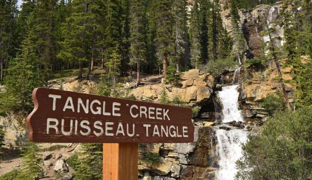
9. Tangle Creek Falls
- Distance from Lake Louise: 165 km (about 2 hours 30 minutes)
- Time needed: 10 to 15 minutes
- Difficulty: Roadside viewpoint
Tangle Creek Falls is one of the most photogenic small waterfalls on the parkway — and one of the easiest stops to make. The waterfall is right beside the highway. You pull off at the marked viewpoint, walk a few steps, and you're looking at a multi-tiered cascade tumbling down moss-covered rocks.
The waterfall has multiple drops and creates beautiful misty conditions in late afternoon light. It's a favourite of photographers because you can capture the whole thing in one frame.
Honest tip: Tangle Falls is on the east side of the highway, but the parking lot is on the west side — meaning it's easier to access when you're driving south (Jasper to Lake Louise). If you're going north, you'll need to be careful crossing the highway.
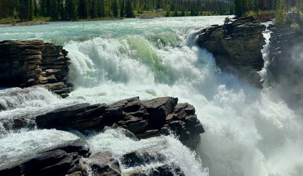
10. Athabasca Falls
- Distance from Lake Louise: 200 km (about 3 hours)
- Time needed: 30 minutes to 1 hour
- Difficulty: Easy paved paths
The final major stop before Jasper. Athabasca Falls isn't the tallest waterfall in the Rockies, but it's arguably the most powerful. The Athabasca River squeezes through a narrow gorge, creating an explosion of water that you can hear before you can see it.
A network of paved walkways and viewpoints surrounds the falls, letting you see them from multiple angles. The mist alone is impressive — you can feel it on your face from the viewing platforms.
The falls also offer a great geology lesson: you can clearly see how the river has carved its way through layers of limestone, creating potholes and a long-abandoned channel that once held the river.
Honest tip: This is the most accessible major waterfall on the entire parkway. It's a great final stop before driving into Jasper. Plan 30 to 60 minutes here, then continue the last 30 km into town.
How to Pick the Best Stops for Your Itinerary
If you have time for all 10, do all 10. But if you're crunched for time, here's how I'd prioritize.
- You only have time for 3 quick stops: Peyto Lake, Athabasca Glacier, and Athabasca Falls. These are the iconic three.
- You have a half day (5 stops): Add Bow Lake and Mistaya Canyon to the three above.
- You have a full day (8 to 10 stops): Do everything on this list, plus Saskatchewan River Crossing for lunch.
- You want the easiest, most accessible stops: Bow Lake, Peyto Lake, Weeping Wall, Tangle Falls, Athabasca Falls. All have minimal walking and clear viewpoints.
- You want the most adventurous day: Hike Parker Ridge in the morning, walk to the Athabasca Glacier toe in the afternoon. Combine with Bow Lake and Mistaya Canyon for shorter stops.
A Suggested Full-Day Icefields Parkway Itinerary
Here's a tested itinerary you can follow as a starting point.
7:00 AM: Leave Lake Louise. Fill up your gas tank before you go.
7:45 AM: Stop at Bow Lake. Walk down to the shore for photos.
8:30 AM: Drive to Peyto Lake. Walk up to the viewpoint.
10:00 AM: Stop at Mistaya Canyon. Short walk to the bridge.
11:00 AM: Quick stop at Saskatchewan River Crossing for gas, washrooms, and a snack.
12:00 PM: Pull off at The Weeping Wall for photos.
12:30 PM: Stop at the Big Bend viewpoint at the top of the hill.
1:00 PM: Parker Ridge trail for a 2.5-hour hike (skip if you'd rather take it slow).
4:00 PM: Columbia Icefield — walk to the glacier toe and visit the Icefield Centre.
5:30 PM: Quick stop at Tangle Falls.
6:30 PM: Athabasca Falls as your final stop before Jasper.
7:30 PM: Arrive in Jasper for dinner.
That's a full day. If you're not into hiking, skip Parker Ridge and use the extra hours to slow down at the other stops.
What to Pack for the Icefields Parkway
A few essentials for a day on the road:
- Full tank of gas — fill up before you start
- Water and snacks — there's only one place to buy food along the route
- Layers and a waterproof jacket — mountain weather changes fast
- Sturdy walking shoes — most viewpoints involve some walking
- Sunglasses, sunscreen, lip balm
- A camera with a wide-angle lens
- Binoculars — wildlife sightings are common
- Offline maps downloaded to your phone
- Reusable water bottle — fill up at the Icefield Centre
In winter, also add: a warm jacket, gloves, a hat, snow boots with grip, microspikes for icy trails, and an ice scraper for your car.
Practical Tips for Driving the Icefields Parkway
A few last things that will make your drive smoother.
Wildlife is real. Black bears, grizzlies, bighorn sheep, mountain goats, elk, and moose all live along the parkway. Slow down at dawn and dusk. Never get out of your car for a "bear jam."
Don't park on the shoulder. Many of the most scenic stretches don't have official pullouts. Park only at marked viewpoints — RCMP do ticket illegal stopping.
Drive both directions if you can. The views look completely different heading south. If you have multiple days, drive the parkway in both directions.
Stay overnight near the Columbia Icefield. The Glacier View Lodge is the only major hotel along the parkway — pricey but unforgettable. Camping is also available at Mosquito Creek, Waterfowl Lakes, Rampart Creek, and Wilcox Creek campgrounds.
Check for road closures before you go. The parkway sometimes closes due to snowstorms, avalanche control, or wildlife management. Check Alberta 511 or the Parks Canada website before you leave.
Build in buffer time. Every stop takes longer than you think. Plan for 30% more time than your schedule says.
Final Thoughts: The Best Stops on Icefields Parkway
After all my drives on this road, the thing that still surprises me is how the parkway keeps revealing new views. Every turn shows you something else. Every stop is genuinely worth getting out of the car for. And no photo ever fully captures what it actually feels like to be there.
If this is your first time driving the Icefields Parkway, take it slow. Don't try to see everything. Pick your stops, plan your day around them, and let the rest of the drive surprise you. Stop at Mistaya Canyon. Hike Parker Ridge if you have the legs for it. Walk to the toe of the Athabasca Glacier. Watch for wildlife. Pull over when a view feels right.
This is one of those drives that becomes a memory you carry forever. Make sure you give it the time it deserves.
For more guides on the Canadian Rockies — including detailed posts on Banff, Jasper, Lake Louise, and the full Edmonton-to-Jasper drive — keep exploring AlbertaTourist.com. We're here to help you discover the parts of Alberta most travellers never get to.
Frequently Asked Questions
How long is the Icefields Parkway?
The Icefields Parkway is 232 km long, running between Lake Louise in the south and Jasper in the north along Highway 93. Some sources cite longer distances (up to 288 km) because they include the drive from Banff townsite to Lake Louise as part of the full route.
How long does it take to drive the Icefields Parkway?
Without stops, the drive takes about 3 to 3.5 hours. With realistic stops at the major viewpoints, plan on 8 to 10 hours for a full day. Two days is ideal if you want to hike or really enjoy the views.
What is the best time of year to drive the Icefields Parkway?
Summer (mid-June to early September) is the easiest and most popular season. All viewpoints, trails, and facilities are open. Fall (late September to early October) offers golden larches and fewer crowds. Winter is possible but requires careful planning, since the road can close during snowstorms.
Are there gas stations on the Icefields Parkway?
There's only one gas station on the entire 232 km route, at Saskatchewan River Crossing, about halfway through. Prices are notoriously expensive. Always fill up in Banff, Lake Louise, or Jasper before you start.
Do you need a Parks Canada pass for the Icefields Parkway?
Yes, a valid Parks Canada Discovery Pass or daily pass is required to stop anywhere along the parkway. Important 2026 update: Parks Canada has made admission free from June 19 to September 7, 2026, as part of the Canada Strong Pass program.
What is the most beautiful stop on the Icefields Parkway?
This is the great parkway debate. Peyto Lake is the most famous, Bow Lake is the most peaceful, the Athabasca Glacier is the most humbling, and Mistaya Canyon is the most underrated. The honest answer is to see all four if you can.
Can you drive the Icefields Parkway in one day?
Yes, but it'll be a long, full day. The drive itself takes 3.5 hours, and the major stops add another 5 to 7 hours. Many travellers split it into two days with an overnight near the Columbia Icefield.
Is the Icefields Parkway open year-round?
The parkway is technically open year-round, but it can close temporarily in winter due to snowstorms, avalanches, or maintenance. Check Alberta 511 before you go in winter. Summer is the safest and easiest time to drive.
Is there cell service on the Icefields Parkway?
No, most of the parkway has no cell service. Download offline maps before you leave and tell someone your plans before you go.
How do I avoid crowds on the Icefields Parkway?
Start at sunrise, visit popular stops like Peyto Lake before 9 AM, drive in the off-shoulder seasons (late May or late September), and consider doing the drive on weekdays rather than weekends. The further north you go on the parkway, the quieter the stops typically are.